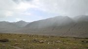
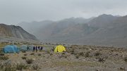
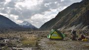
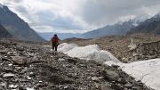
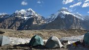
Up Biking and hiking in Kyrgyzstan (July 23 to August 24, 2013) » Trek Mayda Adyr - Khan Tengri Base Camp (August 1-9, 2013) Slideshow

First part
We leave our bikes at the Camp and take our backpacks, which we carry on the bike like a pannier, for 9 days to trek along the Enylchek River and then Glacier to the Khan Tengri base camp just 1400m higher (as for all names there exists a variety of spellings, for an overview on the glacier see here ). Except for the 2 first ones, the altitude gained at the end of each day is little compared to the never-ending ups and downs. We take some food with us, but we rely on getting a meal at most camps, we have been told that this should work. But indeed, the camp guardians are not supposed to host individual travellers, only Aksai groups; but how could they refuse when they have food, moreover it provides them some “pocket money”, they ask you to “pay what you want”; but why Aksai sells only complete packages, including guides and porters? We don’t want that, we just can’t carry food for 9 days.

Day 1: 22km of flat terrain to At Jailoo, simply meaning “next to the pasture”
The road goes further to At Jailoo, and we are told that “there may be a car going up, or maybe not”, thus we start walking. There are some pastures on the way, but very few, there are enough pastures closer to inhabited places. In the afternoon, the sky gets more and more threatening and the packs heavier and heavier, but we can finally guess the camp. And then, just 3 kilometers from the goal, a minibus arrives with 3 Russian alpinists planning to climb Pik Nansen at the lower part of the glacier. A German trekking group arrives in the night, with the result that there is no breakfast for us … but Galia, the camp guardian, is very embarrassed and makes us getting up an hour before the group so that we can get some bread and tea, and don’t leave hungry.

Day 2: 19km of still flat terrain to the camp at the glacier toe
Today we have to pass the main difficulty of the trek, we must wade through the At Jailoo Stream early in the morning … but even then, the water flows very fast and the muddy water doesn’t allow estimating the difficulty. We are very happy that our Russian friends go first, to find out that the water is less deep than it looks like. We just get very cold feet. But soon there is a second difficulty; we must cross twice a large arm of the main river or try to avoid that by finding a way in the slope above the river … which is the option we choose. Fortunately, our Russian friends are there to “clear the path” through the thick and prickly brushwood, not sure that on our own we would have been brave enough to insist; it’s really bad terrain, and an occasion to learn swearing in Russian, but after almost 2 hours, or even more, we are through. The afternoon goes quietly chatting in German … except for a few smaller streams to cross, some by jumping, some by taking off the shoes. We arrive at the camp before the real rain.

Day 3: about 10km to the Glina camp, meaning “clay camp”
This is the first day on the glacier; first not very visible but mostly a moraine, but then there are also huge crevasses and glacier lakes … and some more streams to cross. They are less difficult for us than for the (pretty novice) porters of the German group. The group has a guide but the porters are supposed to find their way on their own. They follow us, and our walking sticks bring finally everyone on the other side. The Glina Camp bears well its name, in wet weather it’s a real mud camp, and in the early evening it starts raining. It’s comfortable to eat together with the group in the kitchen tent.

Day 4: less than 10km to the Merzbacher Observatory
We start well after the others in order to let dry the muddy tent. We succeed, but this short walking day starts grey and rainy. An hour before the camp, we arrive on a large green meadow, which is surprising at that place. Also the camp is on a large meadow, situated where Enylchek forks into a North and South branch. The curious Merzbacher Lake, that suddenly empties once a year ( here is a paper on that lake ), is on the North, whereas we follow the southern branch. It is a beautiful place where the university of Potsdam has an observation station ( some info ). It is almost crowded here! Two organized groups, and four young Austrians who arrived over the Tuz pass.

Day 5: 14km to the Komsomoliets Camp on the glacier
All others visit the Merzbacher Lake; but as the lake is empty, we decide to leave the crowd behind. It’s the first day that we leave the side moraine and progress really on the glacier: “at the big stone with the sign, turn left, traverse the white moraine, and once you are on the black moraine you continue straight until the camp” … that’s the theory; first, we never find this big stone, and once on the black moraine --- after some adventures --- there is no “straight”; there are crevasses to walk around all the way long, and the path is not well marked, the best is to stay on the ridge … as long as this is possible. The last hour is great, we walk on ice and the camp guardian, has marked it so well, you could find it in the fog. It’s a beautiful day with great views changing all day long; especially on the south side where several huge glacier valleys flow in, and new summits appear when passing by. At the camp -- Komsomoliets is the name of the glacier flowing in at that place -- we are alone with Dima and Natalia, the two guardians who do this job for the first time … and find it a far too lonely place

Day 6: 14km to the Dikki Camp
Dima explains us the way to the next camp, “follow the moraine, and then turn left, the camp is a bit off the main glacier on the Dikki glacier”. For a while it’s rather easy, just plenty of ups and downs, sometimes the path is quite well marked and sometimes not at all … anyway there are many cairns, some of them probably old ones. It’s a beautiful day, and only one glacier flowing in from the south, the huge “Proletarskii Turist Glacier”. In the afternoon we get the first view of the magnificent Khan Tengri pyramid.
When it gets time to “turn left to the Dikki camp”, there is not a single mark, the glacier between us and the camp is quite ascending with deep crevasses all over the place; without a well-marked path, there is no way crossing here --- just an hour before sunset. We decide to continue for another kilometer to reach the camp passing on a flatter and less tormented part of the glacier. Probably, we should have turned left even further down, but this is a safe way; we arrive just at sunset at the camp. There are several persons arriving from the base camp. And there are two Spanish alpinists coming down from one of the summits above the camp, not even 5000m but impressive … the ridge above the camp from the trekking peak Pesni Abaya to Neru is absolutely fantastic. We are now at 4000m, the nights are cold.


20130801-005-Trek
20130801-006-Trek
20130801-010-Trek
20130801-011-Trek
20130801-013-Trek
20130801-014-Trek
20130801-015-Trek
20130802-017-Trek
20130802-018-Trek
20130802-020-Trek
20130802-022-Trek
20130802-023-Trek
20130802-025-Trek
20130802-026-Trek
20130802-026b-Monique-Trek.NEF
20130802-027-Trek
20130802-030-Trek
20130802-031-Trek
20130802-034-Trek
20130802-037-Trek
20130802-038-Trek
20130802-039-Trek
20130803-041-Trek
20130803-044-Trek
20130803-045-Trek
20130803-047-Trek
20130803-049-Trek
20130803-051-Trek
20130803-052-Trek
29
Trek to the Khan Tengri Base Camp: Toe of the glacier to "clay camp"
8/3/13 11:21 AM
1280x720 (1009kB)
20130803-054-Trek
20130803-057-Trek
31
Trek to the Khan Tengri Base Camp: Toe of the glacier to "clay camp"
8/3/13 2:09 PM
1120x720 (740kB)
20130803-059-Trek
32
Trek to the Khan Tengri Base Camp: Toe of the glacier to "clay camp"
8/3/13 2:33 PM
1279x720 (932kB)
20130803-062-Trek
33
Trek to the Khan Tengri Base Camp: Toe of the glacier to "clay camp"
8/3/13 8:43 PM
1169x719 (944kB)
20130804-063-Trek
20130804-065-Trek
20130804-068-Trek
20130804-069-Trek
20130804-070-Trek
20130804-071-Trek
20130804-073-Trek
20130804-074-Trek
20130804-077-Trek
20130804-078-Trek
20130804-079-Trek
20130805-081-Trek
20130805-082-Trek
20130805-087-Trek
20130805-088-Trek
20130805-091-Trek
20130805-092-Trek
20130805-094-Trek
20130805-096-Trek
20130805-097-Trek
20130805-098-Trek
20130805-100-Trek
20130805-101-Trek
20130805-102-Trek
20130805-104-Trek
20130805-105-Trek
20130805-108-Trek
20130805-109-Trek
20130805-111-Trek
20130805-112-Trek
20130805-113-Trek
20130805-114-Trek
20130806-115-Trek
20130806-117-Trek
20130806-120-Trek
20130806-121-Trek
20130806-122-Trek
20130806-123-Trek
20130806-124-Trek
20130806-126-Trek
20130806-127-Trek
20130806-128-Trek
20130806-130-Trek
20130806-131-Trek
20130806-135-Trek
20130806-132-Trek
20130806-137-Trek
20130806-140-Trek
20130806-141-Trek
20130806-142-Trek
20130806-144-Trek
20130806-145-Trek
20130806-149-Trek
Merzbacher-paper
87
12/30/13 1:49 PM
(1.3MB)

87 Images | SG | Create web photo albums with Jalbum | Chameleon skin | Aide